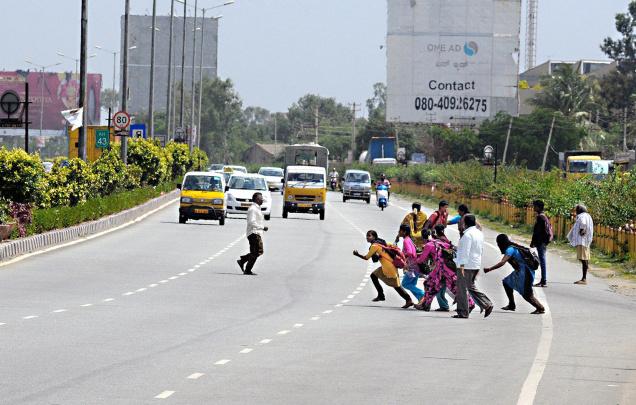
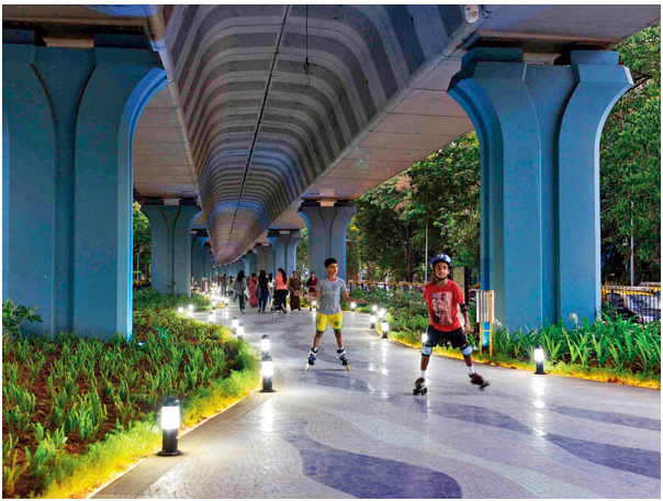
What kind of city do you want to live in? Where a high speed road runs through the city and children risk their life to cross it? Or one where fast moving vehicles run on an elevated road and the ground below is available for children to play?
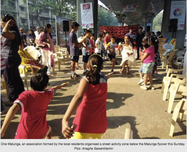
The image 1 above is the current state of Ballari road in Bengaluru. Image 2 is the Nanalal D Mehta garden under Matunga flyover in Mumbai. Image 3 is Kids zone organised on a Sunday under the same Matunga flyover.
Do you want your children to inhale the toxic exhausts from vehicles on jammed roads? Or should vehicles run quickly on elevated roads, leaving neighborhoods with less pollution?
If your choice is a safe neighborhood, with enough space for children to play and for local vehicles to ply, without having to share the road with high speed vehicles going to two national highways, please support the Hebbal Steel Flyover project.
If you have doubts on whether the proposed flyover is good for Bengaluru, please read the below questions and answers, and convince yourself that the flyover is a welcome relief for our beloved city.
Questions and Answers:
- Why do we need a flyover from Basaveshwara Circle (near Rajbhavan) to Hebbal junction?
- Is there a mobility plan for Bengaluru?
- Why do we have to demolish two flyovers, an underpass and two skywalks to build this flyover?
- Is this not a VIP flyover to the airport?
- Why can’t we promote public transport instead of building flyovers?
- Why should we build a steel flyover?
- What about claim by experts that Flyover only moves congestion elsewhere?
- Why can’t we build a metro on this route instead?
- Which other city has an elevated freeway passing through the city?
- Didn’t Mr. Nitin Gadkari, who built lots of flyovers in Mumbai, regret it?
- The problem is at Hebbal junction. Why can’t we fix that?
- The Outer Ring Road from Silkboard to KR Puram has worse traffic. Why can’t we fix that first?
If you are convinced about our arguments, please support the flyover project by signing the below petition. Thanks.
https://www.change.org/p/chief-minister-of-karnataka-i-support-hebbal-steel-flyover
- Why do we need a flyover from Basaveshwara Circle (near Rajbhavan) to Hebbal junction?
Ballari road is part of the old National Highway 7. Hosur road forms the southern portion of this old highway. This old NH7 corridor divides Bengaluru vertically and all important roads of Bengaluru intersect with it. When Outer Ring Road was built, the portion from Silk Board to Hebbal on ORR was declared the National Highway 7 instead of the north-south Ballari/Hosur roads.
So elevated roads on this very important North-South corridor with adequate exits (ramps) will benefit the whole of Bengaluru.
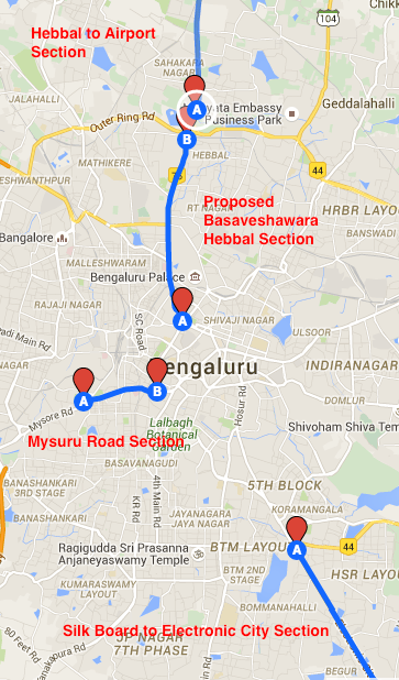
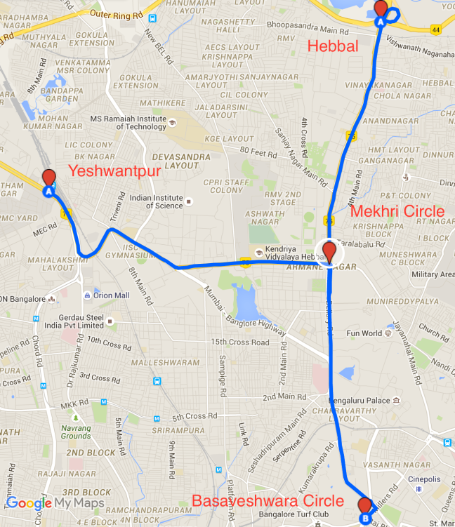
The East-West corridor from Mysuru road to Old Madras road should also have elevated roads. Mysuru road already has an elevated portion built as early as 2000. That flyover already helps vehicles to avoid the crowded KR Market and Bengaluru Fort area. It brings traffic from Mysuru road to near Corporation Circle. The aim of this new flyover is similar. See map below.
- Is there a Mobility plan for Bengaluru?
Ofcourse there is. Transport is part of the Master Plans made for the city. Current metro construction is based on the plans envisioned in Master Plan 2015. Master Plan 2031 is yet to be released because of some political controversies. Proposed elevated corridors, new metro lines on ORR and to Airport will all be part of Master Plan 2031.
Bengaluru Transport Vision:
Neighbourhood traffic – by walk (TenderSURE), bicycles and feeder buses.
Intra-city traffic – Namma Metro, Big 10/Trunk/Connect bus system, ORR buses.
Suburban traffic – Commuter Rail Service connecting to Metro.
Inter-city traffic – Elevated north-south (including Hebbal Steel Flyover) and east-west road corridors, Peripheral Ring Road (including NICE road).
- Why do we have to demolish two flyovers, an underpass and two skywalks to build this flyover?
The underpass at Cauvery junction, built with magic box, was so badly designed that Bengaluru Traffic Police have already closed it (now re-opened to facilitate this steel flyover construction). It was a single lane underpass from Sankey Road to Ballari road in one direction.
The flyovers at CBI junction and near BDA office are again badly designed. There is a small way below the flyovers which doesn’t benefit surrounding areas. An elevated corridor will mean that the road doubles. One above for long distance traffic and one below for criss crossing neighborhood traffic. You can already see this on Hosur Road and Airport Road elevated corridors.
The skywalks at Chalukya circle and near Mekhri circle may not even be needed if fast moving traffic is on elevated roads. They can be replaced with pedestrian crossings. If needed subways can be built at the same locations.
- Is this not a VIP flyover to the airport?
No, it is not. There is already an elevated road from near the airport to Hebbal junction. Most of the traffic on this elevated road is bound for interior Karnataka and Hyderabad Karnataka region. More than a thousand buses ply every night on this stretch. The elevated road also benefits traffic bound for Doddaballapur.
Similarly, there is an elevated road from Silk Board to Electronic city and from there to Hosur. The gap between Hebbal and Silk Board was proposed to be covered by two other projects already.
a. Signal free corridor on Hosur road with a series of underpasses. The Madiwala underpass was built with this in mind. There are other proposals for St. John hospital junction.
b. Recently there is a proposal to build 5 elevated roads criss-crossing Bengaluru. This is being discussed in BMPC, BBPAG and other fora.
This Basavesra Circle-Hebbal flyover will also have a ramp at Mekhri circle to connect city center to the Yeshwantpur via C V Raman Road. People in heavily populated Malleswaram, Rajajinagar, Sadashivanagar, Vasanth Nagar will benefit from this elevated road.
Two national highways, current NH4 and erstwhile NH7. - Why can’t we promote public transport instead of building flyovers?
Public transport is already being heavily promoted.
- Bengaluru city has the largest bus fleet (6000+ buses operated by BMTC) among Indian cities.
- Metro construction is at its fastest pace, with Phase 1 slated for completion at the end of 2016 or early 2017.
- Work on Phase 2 metro has already started, besides the newly added ORR section.
- BMTC has recently introduced an app for real time tracking of buses.
- Karnataka is the first state in India to have a comprehensive Cab aggregator guideline.
- Bengaluru Airport has a separate dedicated pick up area for app-based cabs. There is a running line of Airport cabs like in US airports.
- Karnataka Tourism department (KSTDC) itself runs one of the airport cab services.
- BMTC organizes Bus day every month.
- A number of feeder buses connect people to Metro stations.
- Metro has a smart card which is going to be integrated with BMTC as well.
Given all this, to say that Karnataka govt doesn’t promote public transport will be a blatant lie.
- Why should we build a steel flyover?
Karnataka is a major iron ore and steel producing state. Most of our iron ore gets exported to China via Karwar port. Why cant we use locally produced steel for flyover construction in Bengaluru?
A recent supreme court order asked govts to use the revenue from Iron ore for local development. Karnataka govt has already announced a new railway line from Tumakuru to Davanagere via Sira, Hiriyur and Chitradurga. This is to use the iron ore funds for local development.
Karnataka is not a major cement producing state. International Steel prices are low because of low demand. Using steel will help the local industry in Karnataka. As long as there is no conclusive civil engineering argument against using Steel for flyovers, there is no reason why we cant use in Bengaluru. Its not just the Basaveshwara Circle-Hebbal flyover which is proposed to use steel. Minerva Circle to Hudson Circle flyover is also planned as a steel flyover.
- What about claim by experts that Flyover only moves congestion elsewhere?
Yes, that is true with shorter flyovers. What is proposed is a long (more than 60 kilometers) elevated corridor from Devanahalli to Electronic city. When the steel flyover comes down near Hebbal junction, the traffic will disperse onto Outer Ring Road and the NH7 Elevated road that starts near Esteem Mall. Hebbal junction itself is being remodeled. A new underpass is coming up on ORR. Another flyover from ORR to NH7 is going to be built.
On the Southern End, there is not going to be single entrance but several ramps from Vidhan Soudha, Rajbhavan road etc. The CBD itself is being majorly upgraded with TenderSURE roads. Eventually there will be a flyover from CDB to Silk Board on Hosur road.
- Why can’t we build a metro on this route instead?
Metro is for city traffic. Not for inter-city traffic. When this flyover is built, Ballari, Hyderabad, Tumakuru, Davanagere, Nandi Hills and Airport bound traffic from all parts of Bengaluru can use this elevated route, leaving the city traffic unaffected.
Besides, Phase 2, Phase 3, and metro line on ORR between KR Puram and Silkboard, are already planned after wide consultations. BBMP has provided 8 different routes, and is seeking the opinion of people. to choose for the airport metro line.
- Which other city has an elevated freeway passing through the city?
Lots of cities. Phoenix, Kualaumpur, Los Angeles, Mumbai to name a few.
No major city in the world relies only on small streets for mass transit. Every major city has a large mass transport corridor, of freeways, metro or suburban railway line. Metro in Bengaluru is only getting started. NYC, Paris, Tokyo which have Metro as the core model, have had their system for atleast 50 years now. Mumbai, Chennai which rely on suburban rail, have had their system for nearly 100 years. Mumbai has Western Express Highway running through the city.
Metro and Rail take time to build. So cities like Phoenix (I10, I17), Los Angeles (I5, I10, I405), Kualalumpur have a grid of elevated roads. Even the famous Strip in Las Vegas is pedestrian friendly because most vehicles take the Las Vegas Freeway that runs parallel to the Strip. Mumbai vertically divided by Western Express Highway
 Strip is possible because of Las Vegas Freeway that runs parallel.
 Kualumpur has elevated roads very similar to what is planned for Bengaluru.
 - Didn’t Mr. Nitin Gadkari, who built lots of flyovers in Mumbai, regret it?
Yes, because the Western Express Highway was badly designed. Instead of building an elevated corridor, it is a long series of small flyovers which requires long distance and neighourbood traffic to use the same lanes. In Bengaluru, 27 kms of elevated corridor already exist. This section from Hebbal to Rajbhavan is an addition to existing and widely used elevated north south corridor. Infact this elevated corridor will replace 2 badly designed small flyovers and the disastrous magic underpass at Cauvery junction.
- The problem is at Hebbal junction. Why can’t we fix that?
Hebbal junction redesign work has already started! Work on underpass on Outer Ring Road from Mathikere side to Nagawara side has started. The ramp that goes from Ballari road to Nagawara side is going to be demolished and traffic sent to this new underpass on the left. There is a new flyover proposed from ORR Nagawara side to Ballari Road (joins at Esteem mall). So when the vehicles alight from the new steel flyover, they’ll seemlessly continue to the already existing elevated corridor towards Airport or take the left or right on Outer Ring Road without any signal. Additional lanes are being added to the Ballari road ramp as well.
- The Outer Ring Road from Silkboard to KR Puram has worse traffic. Why can’t we fix that?
Outer Ring Road is already being attended to. A new Metro line from Silk Board junction to K R Puram is being constructed with the collaboration of IT and Software Companies on this stretch. The new steel flyover will infact help divert some of the traffic from HSR, Sarjapura road, which can now take Hosur road to CBD and take elevated road from Chalukya junction. This will help provide relief at Marthahalli and KR Puram junctions.


Great vision and initiative. This remind us Sri. JH Patel who was criticised for Sirsi circle flyover. But see now, he had a vision which short sighted people then didn’t have. Sri. Siddaramaiah will be remembered as on such great CM’s in history. He has delivered in the most difficult of situations. Thank you.
LikeLike
If the master plan is not released in public domain, thereby leaving questions open about its final shape and content, why are parts of measures already been implemented? This is what is confusing a lot of people who are opposing this development. With the limited information that has been shared one doesn’t know if this is not as ad-hoc and hasty as the Cauvery Junction magic box that you speak of.
Details, and a coherent plan could help you ‘sell’ the vision to many. Releasing FAQs and arguments without details is raising further questions and doubts. The current mechanism raises suspicions of vested interests and scares your own constituency that this is an unwarranted and unplanned development activity which is going to blemish the character and form of the city for years to come.
LikeLike
Please share complete details of the project in Public Domain – Design of the project, land required & acquired, environment impact study – 500 trees to be cut, Feasibility Study Report, Detailed Project Report, Tender details, Copy of GoK letter to Union Govt requesting steel at discounted rate – if any, Details of existing infrastructure to be demolished (SkyWalk, Underpass and Bridges), Impact on Heritage, Details of maintenance required after completion of the project, Aesthetic of the city, Details of other infrastructure to achieve the same result.
Why not make use of existing train line and help Public – Public can use SWR Line and Metro for easy travel.
The executing agency, BDA is not sharing any information.
LikeLike
What abt the green coverage being sacrificed.if u dont cut the trees but uproot it and replant it it would be a great for our env.These plant takes years to grow.todays news of planting 3 times is ok.but dont cut the trees.use technic to uproot & replant.
LikeLike
I appreciate the efforts in addressing the bad planning. But are we talking here about only 2 or 4 Lane or 6 lanes? If it is only 4 Lane then chances are we miss out future planning part. There are lots of flyovers still not completed or stopped ex: Near byappanahalli metro, kammanahalki? Most of the space below flyover are being used as a parking lot instead of parks!!!
LikeLike
Misplaced priorities.
Whatever positives you have mentioned can be attributed to Peripheral Ring Road. Additionally, it’ll remove all heavy truck traffic from ORR, provide alternative to badly crowded East. This gov almost treats East of ORR as if it belongs to Tamilnadu and does not provide any help.
For major pain points, why not fix Silk Board and K R Puram; which are much higher priorities than smaller inconvenience faced by Airport going traffic (for which there already is 27KM highway)
For Airport, why not consider alternate road from Budigere instead ? why do we have to cram all traffic from same route.
LikeLike